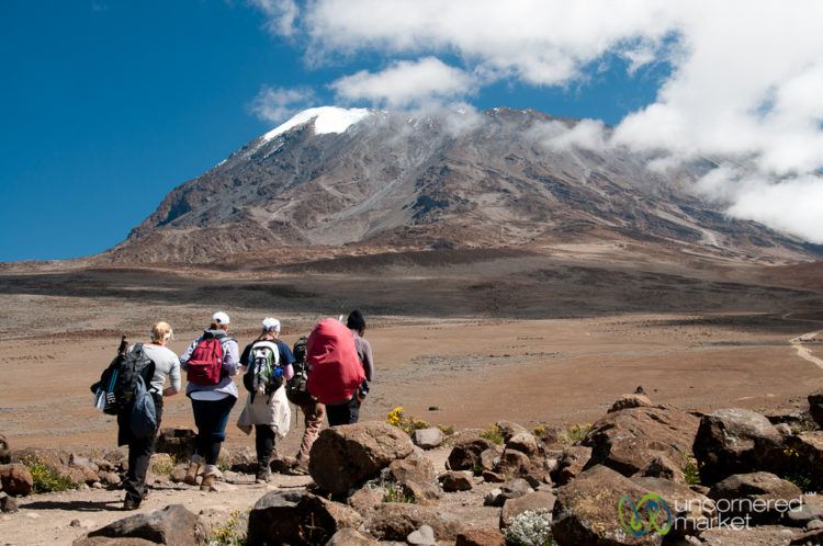
The Mount Kilimanjaro located at coordinates 3º07 ‘S and 37º35’ E in northern Tanzania, near the border with Kenya , is the highest point in Africa, with an altitude of 5,895 m in Uhuru Peak. This ancient volcano, topped with everlasting snow, rises in the middle of a savanna plain, offering a unique spectacle.
The Mount and the surrounding forests, with an area of 75353 ha, have a rich fauna, including many endangered species and constitute a national park that was inscribed by UNESCO in 1987 in the list of World Heritage sites.
The Mount Kilimanjaro complex with its forests, located between 2 ° 50′-3 ° 20’S, 37 ° 00′-37 ° 35’E, had been considered a hunting reserve by the German colonial government at the beginning of the 20th century, but was considered a forest reserve in 1921, until, in 1973, it was declared a National Park.
Knowing The Land:
Mount Kilimanjaro, which shows great volcanic activity in the Pleistocene, is not entirely isolated on the African plains, but is accompanied by three other volcanic cones, oriented on an east-southwest axis: the oldest, Shira to the west, with an altitude of 3962 m, Mawenzi to the east, with an altitude of 5149 m, among them, Kibo, which is the latest and shows signs of activity in the form of fumaroles. Between Kibo and Mawenzi there is a platform with about 3600 ha, called the “saddle” (“the Saddle”), which forms the largest altitude tundra area in Africa. Mount is the most beautiful of all.
Local Stories:
Before the nineteenth century, some rare chronicles, such as that of the Egyptian geographer Ptolemy, mentioned the existence of a “white mountain” in the heart of Africa. In 1845, the British geographer William Cooley, certain of his existence, claims that the best known mountain in eastern Africa is covered with red rocks.
In May 1848, missionary Joseph Rebmann explored the Chagga region and ended up approaching the mountain: “At about 10 o’clock I saw something white on the top of a mountain, and I thought it was clouds, but my guide told me which was the cold; so I recognized with satisfaction this old companion of Europeans, whom we call snow. ” His discovery, disclosed in April 1849 in the Church Missionary Intelligencer, is disputed in London.
It was only in 1861 that an expedition, led by the German Baron Klaus von der Decken and the English botanist Richard Thornton, showed that this was indeed a peak with eternal snows.
In 1883, the Englishman Joseph Thomson, followed by the count Teleki, attack the peak, but they do not exceed the 5300 m. After two failures, Hans Meyer, on October 6, 1889, manages to reach the top of Kilimanjaro, accompanied by his friend Ludwig Purtscheller and the guide Chagga Lauwo. This would have died at age 127 in 1997, but perhaps this story is just a legend, like the story of the presence of a frozen leopard corpse found at 5,500 m.
Temperatures And Facts:
Kilimanjaro is protected by a designated park called Kilimanjaro National Park, classified by UNESCO as a World Heritage Site.
The melting of the glaciers at the top of Kilimanjaro is a reality. Estimates of about 12 km² of extension in 1900, cover today only 2 km², and at this rate will disappear in 2020. The general warming of the Earth does not explain this phenomenon, which may also be caused by a slow resumption of volcanic activity, which manifests itself by small fumes.
The ascent is technically easy, but long and painful by cold and altitude. The most frequent route is the Marangu route. The other routes practiced are the Machame, Mweka and Shira routes. Approximately 20,000 people try to reach the top every year. This number is controlled by the Tanzanian authorities. As a curiosity, Kilimanjaro is the highest point on Earth to have GSM coverage for mobile phones.
Climbing The Mountain:
There are 8 lanes that lead to the peak: Marangu, Machame, Umbwe, Shira, Mweka, Maua, Nanjara, and Loitokitok. The last three are rarely used and the best known are Marangu and Machame. Climbing Kilimanjaro through Marangu and Machame route is very easy and interesting.
Marangu – Also known as tourist route or coca cola, for its popularity and frequency of visitors. It is the most sought after of all and the one that offers the best infrastructure. In it there are cabins with bathrooms and rooms with bunk beds. In the first camps it is still possible to buy water, soda and even beer. Despite all the ease, it has a low degree of success, precisely because it is sought by people not always prepared for the difficult ascension. It is common for cabins to be crowded during high season.
Machame – Considered one of the most beautiful and with a certain degree of difficulty, which forces a slow ascent, essential for success.
Both routes can be done in 5 days, with 3 going up and 2 going down, but an additional day for acclimatization is advisable. On this day, you normally walk at the same altitude, above 3,000m. This really makes a difference for those who are not accustomed to altitude.
Mount Kilimanjaro can be “scaled” throughout the year, but every time of the year advantages and disadvantages are found. April and May are the months of the long rains, November is the month of the fast rains, June to October are dry, but cold and due to the constant fog (June to July), it becomes more difficult to see the mountain. The months of September and October have good weather and low tourist movement. Finally, December to March also have good weather, however they are most wanted and you can have problems with hotel accommodation and camping on the trails.